Our first summit (and a long hike!) at the Adirondack Mountains: What a rush!
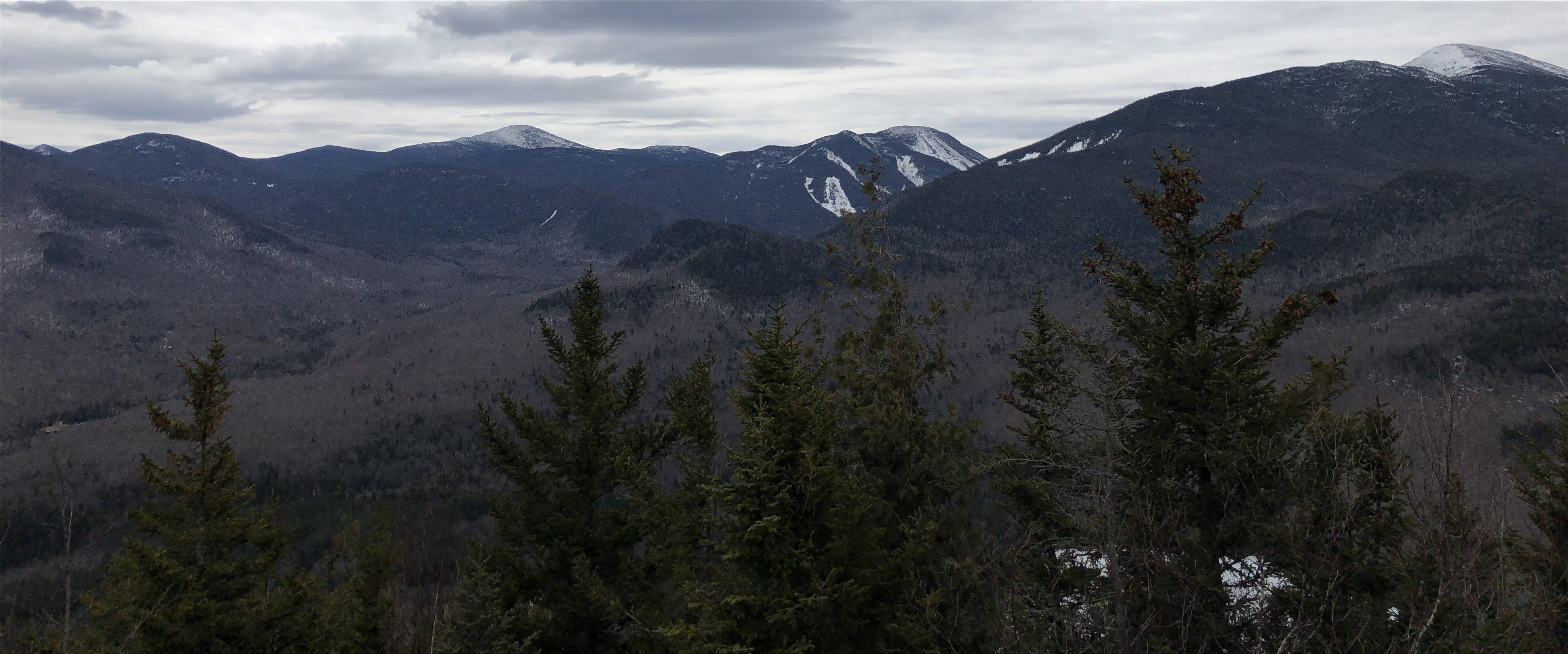 |
| Top of Mount Jo, Adirondack Mountains, NY |
John Muir: “And into the forest I go, to lose my mind and find my soul.”
Back in 2002, my wife and I visited the Adirondack Mountains region, specifically Whiteface/Lake Placid, to do some skiing. We had booked a 5 night/6 day stay at the Mirror Lake area, then skied the beautiful but extremely cold mountains of Whiteface!
We came away feeling rejuvenated after a week’s worth of skiing at the time. We explored the area where we had stayed by doing some shopping and eating out, but the thought of hiking the mountains didn’t even enter our minds at the time.
When the opportunity came to revisit the Adirondack Mountains region in April 2022, we jumped at the chance to finally do some hiking and even summit a mountain! For the month of April, we lucked out when we found a single family home in Tupper Lake, which is about 30 miles away from Lake Placid, via AirBnB.
Using our rental at Tupper Lake as our base camp, we ventured out one cloudy Tuesday morning in April to finally do some hiking in the Adirondacks.
I had done some research prior to deciding on which mountain to hike. That choice came down to our fitness level and our experience summiting a mountain. Our fitness level is moderate at best, while our experience summiting a mountain was pretty much nonexistent.
We had hiked places like Hawk Mountain (Appalachian Mountains, PA) and Seneca Rocks (Allegheny Mountains, West Virginia), but none of these prepared us for our first hike/summit at the Adirondacks. We decided to summit Mount Jo, which is located about 7 miles south of Lake Placid.
There are two reasons why we chose Mount Jo: 1) We found out Mount Jo is considered one of the easiest to summit, and 2) It was on list of many local travel bloggers and national travel sites as one mountain near Lake Placid to hike. These reasons were good enough for me!
We left our ‘base camp’ around 9:30 a.m. and arrived about an hour later at the High Peaks Information Center. High Peaks Information Center is a year round resource for hikers, snowshoers, and cross country skiers. It offers restrooms, as well as any last minute backcountry items like flashlights, trail maps, insect repellents, and trail mix. The information center is where you also pay for parking.
We parked our car near the information center, then headed to the restroom for a pit stop. Afterwards, we went inside to pay for our parking for half day. *Note: They offer either a half day pass or a full day pass. At the time of this writing, half day pass is $7, while full day pass is $15.
We asked the attendant for directions to Mount Jo, and he pointed to the well marked sign near the main gate. In no time, we found the sign, then proceeded to start our hike.


It was a chilly, but refreshing morning to start our hike. We took the gravel path that was muddy and icy on some spots until we saw the sign for Mount Jo, to our right. To our left, we saw the still mostly frozen Heart Lake, with beautiful mountains that seem to be perched right on top of the lake.
After taking in big lungful of fresh, crisp mountain air, we prepared ourselves for the trek ahead!
At the beginning of the Mount Jo trail, the trail is mostly flat gravel path with gradual increase in gradient. After hiking about 10 minutes, we saw the fork in the trail with a choice to make: Long Trail or the more steep Short Trail.
We decided to take the Short Trail as we would be saving about .2 mile to the summit. Note: The Short Trail is .9 mile to the summit while the Long Trail is 1.1 mile.
The Short Trail immediately changed its gradient and we started seeing huge boulders and rocks on the path. We took our time mapping our ascent through the terrain, as some spots still had icy patches and snow.
 |
| Ice on the boulders! |
 |
| Icy patches! |
 |
| More ice on boulders! |
We made sure we stepped on rocks or boulders firmly before moving up, to eliminate slipping on icy patches, with me helping my wife with the ascent. We stopped few times to admire the scenery, and to eat our energy bar and to drink some water.


The further we climbed, the bigger the boulders got! We took careful look at which path to take up the trail, and we made sure we both were in agreement before making the decision.
 |
| Bigger boulders near the summit! |
As the trees thinned out towards the summit, we came upon set of ladders that were nailed to huge boulders. We felt like we were getting close! Giddy with excitement, we made our way up on those ladders until we got to a clearing.
We stopped there to take in the scenery and to get a breather. By then, we were sweating profusely, and we seriously needed to drink some water!


We looked down at the trail we had taken and marveled at the elevation we had managed to cover. We loved the views. Up there, air was even cleaner and more refreshing. We took more life giving deep breaths and made a note at how lucky we were able to do this on a weekday.
After few minutes of appreciating nature, we got up to finish our final ascent to the summit of Mount Jo. It took less than 2 minutes to get there. Oh my, what a view! The summit provides an almost panoramic views of the mountains, with several peaks still covered in snow.
 |
| Mount Jo summit! |


We sat down on one of the boulders to enjoy the scenery, just the two of us! We didn’t see a soul during our hike up to the summit, nor at the summit. We looked far out in the distance to admire the majestic mountains, and to admire the too-many-to-count trees standing tall everywhere.
We smelled scent of pines at the summit which we absolutely loved. We closed our eyes to hear the wind blowing, gently rustling the trees and its leaves in all directions. At times, we heard the howl of stronger winds moving through the air, swaying those trees in violent, dance-like moves. Those sounds reminded me of hurricanes…
We were so proud we had finally summited a mountain in the Adirondacks! We got a sense of satisfaction at our feat, and smiled inwardly and outwardly. It was a feeling of getting a job done well, and we had gotten a heck of an exercise!
After spending few more minutes on the summit, we made our way back. At the fork in the trail down, we had an option of either going down via the same Short Trail, or take the longer but presumably safer, Long Trail. We decided on the Long Trail because we thought the slope wouldn’t be as steep as the Short Trail.
Boy, were we wrong! The supposedly easier Long Trail started out relatively flat and easy (at first), but that was a misnomer. It had too much icy patches about 50 feet in to the descent.
We really had to spend few extra moments deciding on which path to take for our descent. Majority of the trail during the initial descent was covered in ice and/or snow. Snow wasn’t as bad, as we still had traction. Ice, on the other hand, was something to be avoided, if possible.
We didn’t want to slide down the mountain and be hurt or worse. We used boulders and trees/tree branches as much as possible to aid our descent through those icy patches. We took our time getting a sure footing before moving on down.
On the Long Trail, we saw several animal foot prints that didn’t look like dogs’ paw prints. To us, they looked more like a bobcat or some other large cat. The prints had what looked to be claws protruding out, like cats, but not dogs. That added to our trepidation and worry! We really didn’t want to be stuck any longer than we needed to.
I helped my wife who was walking down gingerly, thanks to her slippery boots (and not hiking boots!). Where the ice was prevalent on the main parts of the trail, we took to the sides of the trail, where snow was still visible.
At times, we took longer way down, preferring safety over everything else. We wanted to make it down in one piece, with all our limbs attached and working perfectly.
As we made our way down slowly, we eventually saw less and less icy patches, which was a huge relief. We made good strides in making our descent, carefully following the pink colored ribbon trail markers (indicating that you’re on trail), and we made it past a juncture where the trail branches off to the right to the Rock Garden Trail.
We noticed the almost-absence of icy patches and snow beyond that juncture, and were making good progress when the trail suddenly disappeared! We had been following the same pink colored ribbons tied to trees or branches, but then they just went away.
Slightly panicked, we tried going straight, hoping that was the right way down. We were wrong. We hit too many trees, branches, and overgrown small plants that we couldn’t possibly believe was the correct trail. We couldn’t see any footsteps nor any sign a trail was visible nearby.
My wife and I made a decision (albeit a wrong one now that we look back) to head back the way we had come to take the Rock Garden Trail, which we had passed several minutes prior. By then, we were fairly tired from our ascent, then the slow descent. We had also walked about 4200 steps in the morning as part of our routine walk.
The more we hiked back the way we had come, it became apparent that we were running out of energy. Our energy meter was near empty by that time…
So we stopped and made another decision to go back to the same spot where the trail seemed to end, then search for the trail as best we could. It hindsight, that was the right decision. My wife saw the faint, but pink ribbon wrapped around a tree further down the mountainside!
The trail had been blocked by a fallen tree which impeded our view of the trail we were supposed to be on. After going over the fallen tree, we started to see the unmistakable markings of a typical trail: the footsteps, cleared path, and eventually the trail marker.
We were ecstatic and we hugged each other, half joking that we were alive and that we were going to make it! We made our way down the same trail we had used to climb up, past the split where Long Trail and Short Trail meet.
It took us another 15 minutes or so to make our way back to the same sign we had encountered indicating Mount Jo, to right. Instead of heading straight back to the parking lot, we stopped at the Heart Lake observation deck to catch our breath, and to celebrate us making it back to civilization! We were alive and we survived!!!
 |
| Heart Lake, NY |
 |
| Heart Lake, NY |
We enjoyed our newfound lease on life(?) for few additional minutes before heading back to the parking lot. We noticed we were one of only about a dozen cars parked at the humongous lot. We figured everyone else went to hike other trails, as we didn’t run across anyone while hiking Mount Jo.
When we went into our car, we noticed we had walked over 14,000 steps that day, climbing 40 floors! Wow! Our legs felt like jello and we ached all over from strenuous hike up and down, but boy, that was awesome!

In conclusion:
As exciting and at times scary the hike was, we were exhilarated by our first hike and summit in the Adirondacks. The fact that we got lost, then found our way back was a great hiking lesson, and a great life lesson as well.
In hiking, we learned to stay on trail, even if trail seems to disappear, trusting in the trail markers and our instincts. In life, there will always be hardships. It’s always important to deal with these hardships together.
We learned not to panic, or get angry at each other when things didn’t go our way. Discussing the problem(s) and figuring things out together is why we’re still married in the first place. Had we argued and got frustrated at each other, who knows? Maybe I’m not here right now, comfortably writing this post inside the confines of our AirBnB rental…
For that, we’re really grateful we got back in one piece!
Thank you all for reading!
Jake
Wandering Money Pig
Please click here if you missed our ‘Top 3 things to do in Ocean City, Maryland’.
Please click here if you missed our ‘Top 3 things to do in Atlantic Beach, North Carolina’.
Please click here if you missed our ‘Review of Bushkill Falls and Grey Towers.’
Please click here if you missed our ‘Top 3 natural attractions in Las Vegas’.
Please click here if you missed our ‘Review of Zion National Park’.
Please click here if you missed our ‘Review of Vdara Hotel’.
Please click here if you missed our ‘Review of Chateau at Coindre Hall’.
Please click here if you missed our ‘Top 3 things to do in Oyster Bay’.
Please click here if you missed our ‘Review of Ocean Casino Resort’.
Please click here if you missed our ‘Review of Wildwood Park and Fort Hunter Mansion’.
Please click here if you missed our ‘Top 3 things to do in Ottawa’.
Please click here if you missed our ‘Review of Fiore Suite and classic room at the Borgata’.
Please click here if you missed our ‘Top 3 places with awesome views near Harrisburg, PA’.
Please click here if you missed our ‘Top 3 things to do in Quebec City, Canada’.
Please click here if you missed our ‘Top 3 quintessential places to visit in New York City’.
Please click here if you missed our ‘Review of Ricketts Glen State Park, PA’.
Please click here if you missed our ‘Review of Beaufort, NC’.
Please click here if you missed our ‘Top 3 things to do in Vernon, NJ’.
Please click here if you missed our ‘Top 3 things to do in Harrisburg, PA’.
Please click here if you missed our ‘Top 3 things to do in Montreal, Canada’.
Please click here if you missed our ‘Review of Falls Lake Dam Recreation Area, Wake Forest, NC’.
Please click here if you missed our ‘Top 3 parks to visit in Bogue Banks, North Carolina’.
Please click here if you missed our ‘Review of Niagara Falls State Park’.
Please click here if you missed our ‘Top 3 things to do in Claysburg, PA’.
Please check out our YouTube channel ‘Wandering Money Pig’ showcasing our travels and our Pomeranian dog! https://www.youtube.com/channel/UC3kl9f4W9sfNG5h1l-x6nHw